
The Deccan Traps, India (Part 3): Evidence of recent tectonic activities in Deccan basalts

Mugdha Chimote (India)
The term ‘Quaternary’ is derived from the Latin word “Quaternarius” (meaning “four”, such that the Quaternary is “the fourth great epoch of geological time” in the now-abandoned system of dividing geological time). It refers to the most recent period of the Earth’s history, covering a span of about 1.77 million years extending up to the present day. The Quaternary System is divided into Pleistocene and Holocene Series. The term Holocene was introduced for the part of Quaternary that contains only living species. It covers the last 10,000 period of the Quaternary.
The Quaternary has witnessed some very important events of great consequence, characterised by dramatic climatic changes. It witnessed repeated glacial and interglacial periods, more so than any other period of geological history. Monsoonal wind patterns also developed during this period, and deserts were formed during the latter part of the Quaternary. Although the Quaternary recorded a few extinction events, a great biological diversity still exists on Earth. Most of the present-day species of vertebrates, invertebrates and plants are believed to have remained unchanged during this period.
By now, you must have realised, the Quaternary is not a separate entity of geology. It rather refers to the time period ‘Quaternary’ and all the geological processes pertaining to that period.
Quaternary rocks and sediments are the most recent geologic strata, which lie on the uppermost layers of earth and have been exposed to the least amount of erosion. As such, they are one of the most well studied sedimentary sections and have, in turn, helped construct geochronologies. From my point of view, the very first things that came to my mind when I saw Quaternary sections along the banks of the River Godavari were questions about how sedimentary deposits formed in the Deccan Volcanic Province (DVP)? Although some of my questions remain a mystery to me, I managed to answer most from my list.
The eternal debate over seismicity in DVP
For the better part of the last century, the DVP was considered to be seismically stable. Recent studies of neo-tectonic activities (seismic activities belonging to the Quaternary Period) in Deccan Traps belonging to Maharashtra and Karnataka have raised serious doubts over these claims.
The first chain of thoughts was triggered among geologists after the Koyna (1967) and Khillari (1993) earthquakes. Later, shocks of minor intensities were also recorded from Khardi-Bhatsa and Mokhada areas in the district of Thane, in Maharashtra. The Maharashtra Engineering Research Institute (MERI) recorded micro-seismicity from parts of Pune and Ahmednagar districts during the years 1993 to 1997. Based on these incidents, extensive hydro-geomorphic studies were carried out, and neo-tectonic activities were documented from the coastal and upland region of the DVP. On a regional scale, remote sensing data was used to identify structural elements, such as faults, joints and fractures.
Deccan basalts dominantly consist of compact compound flows, thus making it difficult to decipher faults or other deformations in the field due to the absence of major macroscopic structural elements. However, study of drainage morphology and geomorphic features has helped solve this problem. I adopted a similar approach to study the Quaternary geology in the upstream regions of the Godavari River in Maharashtra. In addition to geomorphic studies, I also conducted tectonic and petrographic studies.
A little background to the study area
The upstream region of River Godavari, in the Nashik district of Maharashtra, India, was first identified as a site of Acheulian industry settlement (Stone Age man belonging to the Lower Palaeolithic Period) by Sankalia in the late 1950s. Since then, in the last 70 years, extensive archaeological and geomorphic studies have been carried out in the region.
I was fortunate enough to be the first person to study this area from a purely geological perspective. So, as part of my master’s thesis, I worked on the neo-tectonic and sedimentological aspects of the region in and around the Godavari River in Nashik District. In this article, I will be talking about neo-tectonic activities in DVP and the evidence for these claims. The second article on this topic will deal with the complete sedimentology of the region.
For better orientation of the study area, see the location map below in Fig. 1.

Drainage pattern and structural control in DVP
The Western Ghat escarpment of the DVP separates the Konkan coastal tract from the upland area inland. The rivers carving the upland plateau have broad valley floors with uneven bedrock surfaces. The Godavari River and its tributaries in the study area show bedrock incision by these rivers. Lineament maps (which show underlying geological structures, such as faults, fractures and joints), based on drainage patterns, represent fractures and dykes trending in NE-SW and N-S directions, respectively (Fig. 2).

The higher order streams exhibit sharp and angular bends along its courses, thus establishing a structural control in the region. This control was substantiated by the studies of two major sets of joints (maxima in NNW-SSE to N-S direction; sub-maxima in NE-SW direction) in the region (Fig. 3).

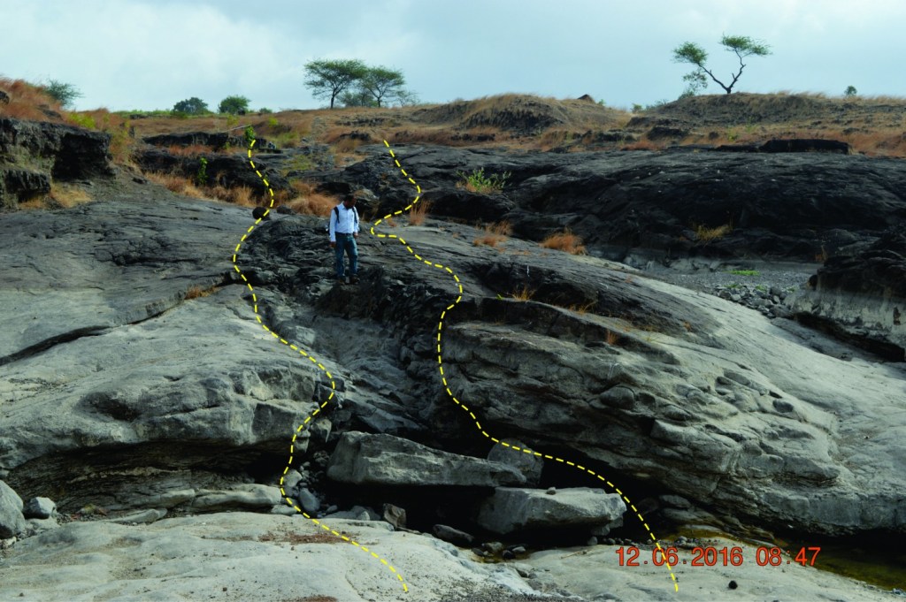
In addition to these, a major fracture trending NE-SW direction, running along the knickpoint of the waterfall in the region, was delineated along the southern bank of the channel. This fracture is filled with extremely fine grained (glassy), dark green material (Fig. 4a). Parallel to this fracture, a fine-to-medium grained dolerite dyke is exposed in the upstream part of the river channel, close to Gangapur Dam (Fig. 4b). Dykes typically tend to occupy pre-existing structures, such as fractures and faults, of varied trends. They follow fractures, especially the ones with least tensile strength and, as they follow another fracture, they branch out. All these field observations established a solid base for possible neo-tectonic activities in Deccan basalts.

To further my claims, I conducted petrographic studies to better understand their textures and microstructures.
Textures and micro-textures
Petrographic studies of the basaltic flows in the region and the green coloured glassy material were carried out. My observations were as follows:
- Basaltic flows. These are medium grained, phyric with glomerocrysts of plagioclase, pyroxene, and occasional olivine in a microcrystalline groundmass, made of fine-to-medium size plagioclase laths and augite grains, irregular opaque minerals exhibiting intergranular texture. The groundmass exhibits a pilotaxitic texture, that is, a flow alignment (Fig. 5a).
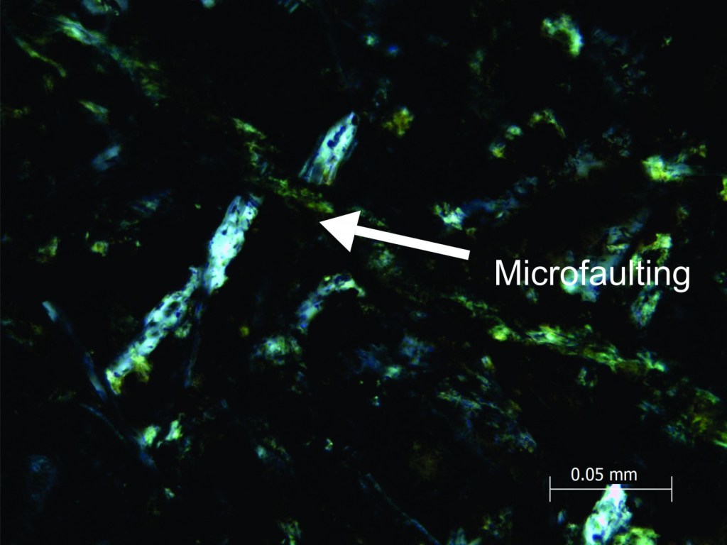
- Green coloured glassy material. The fracture fill material is fine grained with medium sized phenocrysts of plagioclase, augite and olivine, set in a fine-grained groundmass, predominantly made of thin plagioclase laths, opaque minerals, glass and abundant microvesicles. Plagioclase grains of both the phenocryst and the groundmass have been highly altered. Numerous microcracks are also observed in the groundmass, filled with green chloritic material. These cracks are thought to have formed due to induced stresses. Moreover, intergranular cracks/joints are observed within most of the phenocrysts. Pyroxene phenocrysts show curvilinear joints that run along the periphery of the grains (Fig. 5b). Microjoints in plagioclase laths are parallel, linear and regularly spaced, transecting the individual lamellae. Along the micro cracks of these plagioclase grains, micro kinking and micro faulting is observed (Fig. 5c and d).


What do these observations imply?
Based on the field observations and the petrographic studies, it can be affirmed that the drainage morphology, geology and structural features in the region have certainly influenced the topology of the area. Geomorphic features, such as changes in river courses, development of knickpoints, and incised stream channels, are suggestive of tectonic disturbances, as evident from drainage configuration of the area. Furthermore, the parallel stream courses, deflection and angular bends in the streams indicate a strong structural control.
Grain orientations and micro faults observed at the microscopic level indicate local scale deformation that could be related to regional scale deformation. Microstructures, such as micro cracks filled with green chloritic material, micro kinking, and micro faulting in plagioclase grain, observed in the fracture fill material are evidence of deformation. These deformations on microscopic scales may also have been facilitated by coalescence of stress leading to ductile and brittle shear.
Although I have found solid evidence for neo-tectonic activities in the vicinity of Godavari River in Nashik district, similar studies need to be carried out in other regions of the DVP, so that relative comparisons can be drawn in this context.
| This is the third of four articles on the Deccan Traps of India. The others consist of: |
|---|
| The Deccan Traps, India (Part 1): The story of its genesis |
| The Deccan Traps, India (Part 2): Stratigraphy and geomorphology |
| The Deccan Traps, India (Part 3): Evidence of recent tectonic activities in Deccan basalts |
| The Deccan Traps, India (Part 4): Quaternary sediments of the Godavari River basin, Maharashtra |
References
Agrawal, P. K., Pandey, O. P., and Chetty, T. R. K. (2004). Aeromagnetic anomalies, lineaments and seismicity in Koyna-Warna region. Jour. Indian Geophy. Union, v. 8(4), pp. 229-242.
Bhave, N., Siddique, I. M., Desi, J., Pillai, S. P., Dole, G., Kulkarni, H., and Kale, V. S. (2017). Faulting in the Deccan trap in the vicinity of Koyna-Warna Seismic Zone. Jour. Geol. Soc. India, v. 90, pp. 748-751.
Chimote, M., Vaddadi, S., Deo, S. G., et al. (2018). Evidence of Microscale Deformation in Deccan Basalts along Godavari River, Nashik, Maharashtra. Journal of Geosciences Research, v. 3(2), pp. 171-176.
Gohil, B., Deo, S., Joglekar, J. and Pawar, N. (2014). Geomorphological observations at and around the acheulian site of Gangapur, District Nasik, Maharashtra. Bull. Deccan College, Pune, pp. 74.
Kailasam, L. (1979). Plateau uplift in Peninsular India. Tectonophysics. v. 61, pp. 242-269.
Kaplay R.D., Kumar T.V., Sawant, R. (2013). Field evidence for deformation in Deccan Traps in microseismically active Nanded area, Maharashtra. Curr. Sci., v. 105(8), pp. 1051-1052.
Vaddadi, S. and Rajaguru. S. N. (1998). Morphotectonics in the source region of Godavari basin, W. Maharashtra, India. Int. Conf. Stable continental regions, earthquakes, NGRI, Hyderabad-Abs. Vol.