
Miocene-Pliocene shallow water marine fossils at Chippokes Plantation State Park, Virginia

Deborah Painter (USA)
On a cool, early December day in 2020, my friend David Hawk and I decided we simply had to search for fossils after not doing so for months, and also not be stopped by the chill or the coronavirus. Rather, we would prepare for both.
We set off from Norfolk, Virginia USA and drove west to Smithfield, using our GPS to find Chippokes Plantation State Park in Surry County. We found the intersection of Business Route 258 and US Route 10 west of Smithfield, and followed the latter for approximately 22km, before turning right off US Route 10, Virginia to State Route 634. From this intersection, we travelled on 634 for a few kilometres, then right onto State Route 633, and then turned left, which took us back to State Route 634. We then had to climb a steep and winding road through a forested area.
“This had better be worth it”, I grumbled, mostly to myself. After about 15 minutes, we reached the intersection with State Route 665 and saw the sign for Chippokes Plantation State Park.
We paid our seven dollars daily parking fee at the entrance gate and we soon found the car park for the visitors centre. A family with young children arrived at about the same time and quickly took one of the trails.
The car park was only about 40 or so meters from the edge of the bluff overlooking the James River, an estuarine tributary of the Chesapeake Bay. Here, trees grew oddly in bent shapes, formed in that manner by the wind blowing off the water all year (Fig. 1). Many picnic tables and grills were provided. However, even though it was noon, no one was using the picnic area. It was chilly!

We were in luck: it was low tide when we arrived. But before we ventured forth, we wanted to see the museum. It boasts a tiny theatre that screens an entertaining, eight or nine minute film, describing the general history and culture of Surry County. It seems the area has been known for centuries as the “Surry side” of the James, since it is a predominantly quiet rural area directly across the river from Jamestown and Williamsburg, both political centres for many decades during the Colonial Era and just after.
Chippokes Plantation State Park also has the oldest continually operating farm in Virginia. The original owners were wise to build their farm buildings far from the bluff, which has been subject to severe erosion for untold millennia. Erosion has destroyed about one-third of the earthworks of Fort Boykin, a 200-year-old fort, very near the bluffs along the James, near Smithfield.

There are small re-creations of the shoreline at Chippokes (Figs. 2 and 3). Some cases under the windows overlooking the James highlight the many interesting upper Miocene/lower Pliocene epoch fossils. A vertical interpretive display on a wall opposite the cases describes what an epoch is and has the timeline represented at Chippokes in the vertical order in which one would find them in nature, since there has been no tectonic disturbance to the stratigraphy of these Miocene and Pliocene beds (Figs. 4 and 5). Each green display board briefly describes the climate and life here in coastal Virginia at the time.


However, the description for the time 23 million years ago is a bit confusing. It states that few fossils from this time survive, which is an unfortunate choice of words. Perhaps the person who wrote it meant that few fossils from this time have been preserved to the present day in coastal Virginia.
What is exposed is the shallow water marine Chesapeake Group, which may include the following formations:
- Chowan River (upper Pliocene)
- Yorktown (lower Pliocene to lower upper Pliocene)
- Eastover (upper Miocene)
- St Marys (upper and middle Miocene)
- Choptank (middle Miocene), and
- Calvert (middle and lower Miocene).
The Chesapeake Group consists of fine-to-coarse grained sand, silt and clay, and is highly fossiliferous. In some areas, it is diatomaceous (that is, a naturally occurring, soft, siliceous sedimentary rock that can be crumbled into a fine white to off-white powder) and, in others, it is shelly. The Yorktown is found nowhere else but in south-eastern Virginia and eastern North Carolina. It is extensive and underlies most of eastern North Carolina until one reaches the “Fall Line”, which demarcates the coastal plain of that state from the Piedmont. The shallow waters of the Cobham Bay Sea were warmer than the waters of the Chesapeake Bay and its tributaries today, which are remnants of that sea.

There are two trails to the beach (Fig. 6). One leads just past the visitors centre for a short hike and the second, the College Run Trail, is much longer, taking over an hour each way. The bluffs range from 6m to 20m in height. No digging in the bluffs is allowed, but it is unnecessary to do so to obtain fossils. Once you arrive at the beachfront, you will have no trouble at all finding fossils lying loose and it will be a question of how much you think you want to haul in a bag back up the hill (Fig. 7). Commercial scale collecting is not permitted.

“This place reminds me of Fort Boykin’s bluffs with shells,” David commented, mentioning the not-too-distant historic fort that also has abundant fossils.
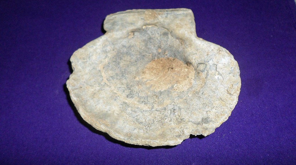
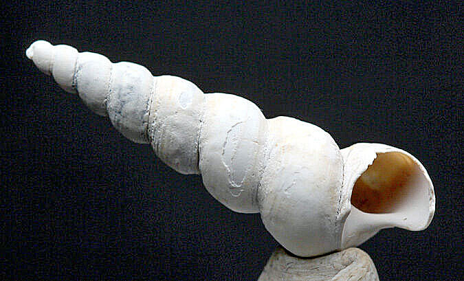
Casts and moulds, original remains and completely or partially permineralised fossils are to be had. Depicted here are three fossils. The scallop is a Chesapecten that is partially permineralised and partially original shell material. The Turritella mollusc is the original remains and is unaltered. The whale inner ear bone is permineralised.
Chesapecten jeffersonius (Phylum Mollusca, Class Pelecypoda) is a large (averaging 9cm to 11cm) extinct scallop species, named for native Virginian and third United States President Thomas Jefferson. It is the state fossil of Virginia (Fig. 8 and Fig. 9.). Closely related is Chesapecten madisonius, named for another native Virginian, James Madison, one of America’s Founding Fathers and the fourth President of the US. We saw dozens of Turritella plebia (Fig. 10), a very common small marine, snail-like animal (Phylum Mollusca, Class Gastropoda), ranging from 2cm to 3cm in length. It is not uncommon to see round holes made by members of this genus in the fossil shells of prey species larger than itself, like bivalves (molluscs, with shells divided into two halves), including the very common Mercenaria cuneata, a relative of the modern Quahog clam.

On the subject of bivalves, if you find a complete bivalve that has not been split open, we recommend you do not open it until you return home. Open it there, and then sift the contents in a sieve. For reasons that are not entirely clear to me, small gastropods, less than 5mm, can often be preserved in the silty, clayey sand. It is wonderful to think that yours are the first eyes to behold them in millions of years.
Barnacles are less common at Chippokes than molluscs. Barnacles are arthropods of Phylum Arthropoda, subclass Cirripedia, named for their feather-like feet called “cirri”. Barnacles do not look much like crustaceans, but are in the subphylum Crustacea, and are related to lobsters and crabs. Those at Chippokes are mostly Balanus concavus proteus.
Phylum Chordata (to which we belong) is represented too. Particularly interesting to collectors, even those who are casual collectors, are the fossil teeth of sharks, particularly mako (Isurus hastalis), and an extinct variety of great white (Carcharodon carcharias).
Cetaceans, related to the modern bowhead whale, have been found in the Chesapeake Group deposits. We were delighted with a permineralised whale inner ear bone (Figs. 11 and 12). While not certain of the genus, we have seen similar whale inner ear bones in the collection of geologist Pamela Painter, collected from the Rices Pit locale in Hampton, Virginia, near the shores of the Chesapeake Bay. Therefore, we feel that, due to similarities in size and shape (11.43cm in length and 10.79cm in width), the specimen, like hers, probably belonged to an individual of the Yorktown Formation species Balaena ricei.


This is a baleen whale, originally named from a complete specimen unearthed by Frank C Whitmore of the Smithsonian Institution in 1960, from the now closed Rice’s Fossil Pit on Harris Creek Road in Hampton. For years, it was a borrow pit (that is, a pit resulting from the excavation of material for use in embankments), but since 2007 has been operating as a fill pit for dredged sand and silt, and not open for fossil studies.
The fossil collecting locality along the Chippokes beachfront shares the Miocene-Pliocene Epochs with one other state park within a two hour drive allowing limited collecting. This is Westmoreland State Park, at 145 Cliff Road in Montross, Virginia, which has Chesapeake Group fossils. Another much closer state park that allows collecting of Tertiary and Quaternary fossils is the York River State Park at 9801 York River Park Road in the Williamsburg area. Here, one can find younger, Windsor Formation shallow water marine fossils of the upper Pliocene and lower Pleistocene. Chippokes Plantation State Park has as many fossils on the beach as do these two sites.
About the author
Deborah Painter is an ecologist and general environmental scientist. She lives in the United States.
References
Geologic Map of North Carolina: Geologic Map of North Carolina (arcgis.com)
Interactive Geology Map of Virginia, Virginia Department of Mines, Minerals and Energy: https://energy.virginia.gov/webmaps/GeologyMineralResources
Ross, Arnold, 1964. Cirripedia from the Yorktown Formation (Miocene) of Virginia. Journal of Paleontology v. 38 no. 3, p. 483-491.
Sheppard. Nancy. August 13, 2021. WY Daily: Daily News for Southeast Virginia Landmark Lost: Rice’s Fossil Pit: Landmark Lost: Rice’s Fossil Pit | Williamsburg Yorktown Daily (wydaily.com)
United States Geological Survey. Geologic Units in Surry County: https://mrdata.usgs.gov/geology/state/fips-unit.php?code=f51181
University of Maryland Department of Geology. Spring Semester 2021. GEOL 204 Dinosaurs, Early Humans, Ancestry & Evolution: The Fossil Record of Vanished Worlds of the Prehistoric Past: https://www.geol.umd.edu/~tholtz/G204/lectures/204fossils.html
Ward, Lauck W., and Blake W. Blackwelder. 1980. Stratigraphic revision of Upper Miocene and Lower Pliocene beds of the Chesapeake Group, middle Atlantic Coastal Plain. US Geological Survey Bulletin 1482-D. US Government Printing Office, Washington, DC.
This was a very good read. I enjoyed learning about the area,