
Geomodels in engineering: An introduction

Peter Fookes, Geoff Pettifer and Tony Waltham (UK)
This article is based on the introduction to the newly published book Geomodels in Engineering Geology – An Introduction.
What, why and when?
The Earth is an active planet in a constant state of change. These changes can take place over both long and short periods of geological time (thousands or millions of years) or much more quickly on an engineering timescale (minutes, hours or days). Geological processes continually modify the Earth’s surface, destroying old rocks, creating new ones and adding to the complexity of ground conditions: the so-called ‘geological cycle’. The all-important concept that drives this geological plate tectonics.
The benefits geologists bring to construction projects must exceed the cost of their services — that is, they must accurately improve the engineer’s ground knowledge more cheaply and effectively than any other method. They must reduce the risk of geological hazards by anticipating situations perhaps unseen by the engineers and also help to determine effective ways of dealing with risks and any problems arising during design and construction. The main role of the engineer geologist is to interpret the geology and ground correctly. Creating an initial model for the geology of the site is an excellent start. Geology (the study of the Earth) and its closest geo-relative, geomorphology (the study of the Earth’s surface), are concerned with changes over time and any geomodel has to build in any changes likely to occur in the near future, especially when the construction project may have a significant impact on the environment (Fookes, 1997).
Some degree of uncertainty will always exist in both the interpretation of the existing geology and any anticipation of significant changes over the lifetime of a project. The key types of uncertainty include data uncertainty and environmental uncertainty. Some aspects may defy the precise prediction conditions — for example, earthquakes, landslips, our limited understanding of the behaviour of complex Earth systems, or future choices by governments, businesses or individuals that will affect the socio-economic or physical environment. Many assessments rely on expert judgements based on the knowledge available, together with experience from other projects and sites. The problems associated with expert judgements include the poor quantification of uncertainty, poor problem definition and any bias of the assessor.
To paraphrase the above, many, if not most, difficulties in ground engineering arise from either an unawareness of the ground conditions or a failure to appreciate the influence of the known ground conditions on a particular engineering situation.
Geomodels
Geological pictorial models
The three-dimensional models in this book are mainly intended for teaching and are too simple for the more detailed prediction needed on an engineering site when a more detailed understanding of the near-surface geology is required (Figs. 1 and 2). This is developed through the stages of a ground investigation and it is necessary to build a site geomodel for practical use. Such a model is based on engineering geology and ultimately leads to a ’geotechnical model’.


Much has been published in the last decade or so on the use of models in engineering geology, building on a very small number of such papers before this time. It must be emphasised repeatedly that, at any scale, every geomodel is different and must be tailor-made for the current project.
Site models
Before or during the desk study phase of a civil engineering ground investigation, engineering geologists, by virtue of their training and experience, should be able to visualise an initial simple basic model of any part of the Earth’s surface or near-subsurface (a terrain model). We consider that geology taught to degree level is an essential part of the training of an engineering geologist. A geologist is trained to visualise the third (and fourth) dimension of any area. This visualisation improves with experience. The details and accuracy of the model will depend on the location and the individual geologist.
Such models, especially in a new area, help us to understand the three-dimensional geology, near-surface variations and to identify the relevant geomorphological systems and processes and main environmental controls. Other disciplines may well be needed to help evaluate the situation — for example, geomorphology, which is indispensable at many sites, surface and groundwater hydrology, ecology, and specialist seismic and volcanic studies. This is why a specialist ‘geoteam’ is needed. Each site will require consideration of the approach to model-making and the value to be obtained. Interaction with the project’s geotechnical engineers is essential at all stages of production of the model.
As an example, we can consider the construction of very long mineral railways over a large area in the Pilbara, Western Australia, for which little detailed geological mapping existed. In a series of investigations over a number of years, initial conceptual models were first developed to represent the nature of the different terrain units and engineering geological formations (Baynes et al., 2005). Observational models were then developed to present the observed and interpreted distribution of reference conditions in a variety of ways (maps, two- and three-dimensional models, sections). These were followed by evolutionary models, which illustrated the way in which the terrain units, engineering geological formations or the reference conditions had developed over geological time, using a series of sketch maps, sections and block models. The models therefore progressed from two to three to four dimensions.
Geomodels created during the desk study of a ground investigation will allow a better understanding of the site and more efficient planning of the investigation, such as the placing of boreholes, sampling and testing. The models should provoke both direct and lateral thinking, and therefore lead to a more balanced and cost-effective investigation. The models are continually reviewed and improved as the investigation evolves. It is essential to continually check, refine or modify the initial mode so that it becomes increasingly site-specific. This must also include continuous interaction of the geologists with the site and design engineers. Interaction is also needed to make judgements on the management of the geo-risks associated with the project.
Total geology
The total geological concept is required during the ground investigation stages following the early desk study to both develop thoroughly the initial geomodels and to present a comprehensive picture of the ground conditions (Fookes et al., 2000). Unfortunately, this concept is not always foremost in an engineer’s mind as a result of more pressing concerns, such as costs, time, quality and the availability of staff, equipment and materials.
Three-dimensional hand or computer drawings must attempt to incorporate all the individual surface and subsurface components of the site, including the tectonic and structural geology, stratigraphy, geomaterials, ground and surface waters, the local climate and the geomorphological conditions, together with significant surface details resulting from human activities. For a small site, a model may only need a thumbnail sketch; for a larger site, a series of detailed models (of different geological aspects) are probably needed, particularly where future changes to the local environment and process systems, or particular risk(s), are anticipated. The model must also be ‘engineer-friendly’ – that is, easy to understand by those with little geological knowledge.
Other forms of model-making exist and these are being continually developed and becoming increasingly important, particularly through the use of computer-aided studies to evaluate large amounts of data (Culshaw, 2005; Allen et al., 2014).
Geological time: stratigraphy
The age of Earth is of the order of 4,600 million years (4,600 Ma or 46 Ga). The first fossils of simple cells date from about 3,600 Ma and the oldest rocks found on the Earth’s surface date from about 4,400 Ma. Geologists divide the time from the birth of Earth to the present into long subdivisions or Eras and then into shorter Periods. Good indications of age can be given by the correlation of fossils in any sedimentary strata (for example, the remains of shallow marine organisms present in a bed of limestone originally deposited on a shallow sea floor) or by radioactive dating. There are a variety of other ways to approximate the age of rocks by their type and history, such as dendrochronology or varve analysis and relative dating by the law of superimposition.
Surface materials
The current landforms, — that is, the subdivisions comprising the landscape in any region — are the result of the geological and geomorphological history. They may consist of several different types of rocks and soils, many of which will be familiar to geotechnical engineers.
Soils
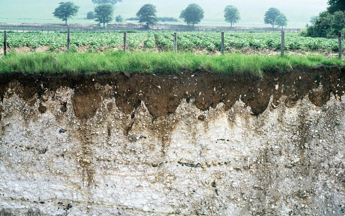
Engineers generally consider any non-lithified (that is, not rocklike) materials overlying solid rock (the bedrock) to be an ‘engineering soil’. These are the ‘overburden’ of engineers or ‘regolith’ of geologists. The overburden may consist of saprolite (in situ weathered rocks and residual soils) and/or a variety of soils transported by gravity, wind, water or glaciers before deposition (Fig. 3).

A small part of Earth’s surface is bedrock that is more or less unweathered, or only a little weathered, as in some hot deserts or glaciated terrains. However, most of the world’s bedrock is weathered and is covered by transported soils or soils developed in situ (for example, tropical residual soils, temperate residual soils or duricrusts in arid lands).
On land, there are also special superficial (‘surficial’ in North America) coverings. For example, the land surface of polar regions may be covered by ice, forest floors may be covered with decaying leaf litter and peaty organic soils may develop in wet areas. Surface clayey soils typically start as under-consolidated clays (Fig. 4).
Rocks
Rocks of similar types occur in suites or associations. The long-term differential weathering and erosion of stronger and weaker rocks are reflected in the various landscapes that have developed around the world.
Rocks are loosely defined in geology as all forms of deposit that are older than the Quaternary Period and, using this definition, some forms of ‘soil’ may be called rocks. Many other firm or loose definitions of ‘rock’ and ‘soil’ exist for engineering situations, including the strength and difficulties of excavation. Engineers may call ancient clay sediments (for example, over-consolidated London Clay, around 40 Ma old) an ‘engineering soil’. This subject is fraught with potential contractual misunderstandings and unambiguous definitions are needed in any contract documents.
There are three main rock types:
- Igneous rocks. Intrusive igneous rocks solidified slowly from hot magma (molten rock generated by heating within the Earth’s crust or upper mantle) before it reached the surface, forming large crystals, for example, granites and dolerites. Extrusive rocks such as basalts cooled quickly from hot surface lava flows and have small crystals, whereas pyroclastic rocks formed from volcanic ejections through a volcanic vent, for example, ash, cinder and larger debris (tephra), making tuffs, agglomerates and volcanic breccia. Intrusive and extrusive rocks tend to be strong and their behaviour may be governed by jointing systems. Pyroclastic rocks tend to be variable in their engineering performance, from weak and friable to strong and tough.
- Metamorphic rocks. These are rocks that have been altered by the effects of high confining pressures and/or high temperatures within the Earth’s crust. Regional metamorphism is a result of both high temperatures and high pressures, and is typically associated with mountain chains along plate collision margins (for example, the Himalayas or Andes). Thermal or contact metamorphism results from the high temperatures around igneous intrusions, which bake the original rock. For example, mudrocks may be altered to shales, slates, phyllites or mixed schists depending on the temperature and pressure conditions. Metamorphic rocks can be broadly divided into three main groups: foliated (or banded), consisting of rocks in which the texture is layered, for example, gneiss; those where the minerals have a preferred orientation, such as schists and slates; and those that are non-foliated — these rocks tend to have high isotropic strengths and low permeability, for example, hornfels and granulite. Foliated rocks tend to be weak parallel to the planes of foliation.
- Sedimentary rocks. These are rocks formed from material derived from pre-existing rocks (i.e. sediment) and those of organic or chemical origin. They form a large part of the Earth’s surface rocks. A distinctive feature of most sedimentary rocks is their stratification or bedding, which tends to control their behaviour. Clastic rocks are composed of particles or fragments that have been deposited from material derived from the weathering and erosion of pre-existing rocks. This is then lithified by compaction and cementation (diagenesis) at low pressures and temperatures to form mudstones, shales, siltstones, sandstones, gritstones, breccias and conglomerates. Chemical sedimentary rocks are typically formed from the precipitation of dissolved minerals, for example, rock salt, gypsum and some limestones. Organic sedimentary rocks, such as shelly limestones, chalk and coal, are formed from the hard parts of animals and plants.
The mineral composition, fabric and porosity of rocks determine their mechanical strength and resistance to weathering. For example, shale is mechanically weak, but is resistant to chemical weathering, whereas limestones are often strong and resistant to mechanical weathering, but are readily soluble under slightly acidic conditions (chemical weathering), resulting in the formation of karst (cavernous) landscapes (Fig. 5).

In general, the older rocks within a particular area tend to be stronger and have a more complex structure than younger rocks. Their geological history is also important and rocks of the same age in different locations (commonly in different tectonic settings) may have very different geological and engineering characteristics.
The Quaternary Period: climate change and the geomodel
The climate has varied throughout the history of our planet, over both geological and historical timescales. Examples of the most important worldwide variations are the four ‘icehouse’ phases, dominated by repeating glacial episodes, and the four ‘greenhouse’ phases dominated by repeating interglacial episodes, which occurred during the Phanerozoic Eon. The slowly changing global distribution of land masses caused by plate tectonic movements has brought about either predominantly icehouse or greenhouse conditions.
Each phase is believed to last about 40 to 95 Ma and greenhouse phases have accounted for about 60% of Phanerozoic time. There have also been special times within the Earth’s history, such as part of the Cretaceous Period, when the Earth was a long greenhouse cycle with no ice sheets over the pole, higher global temperatures and high levels of carbon dioxide in the atmosphere.
The last icehouse phase began in the middle Tertiary, building up to its greatest extent in the Quaternary. It was characterized by frequently occurring repeated climatic changes. Such repeated climatic changes with alternating interglacial and glacial episodes have been significant in the creation of today’s landscapes, especially in the current regions of temperate climate. The ice advances and retreats within an icehouse phase are considered to be mainly – a result of a combination of variations in the Earth’s orbit around the Sun (the Milankovitch cycles) and changes in solar radiation.
In addition to the repeating ice advances and retreats of the Quaternary, smaller changes that have occurred during historical times have influenced geomorphological processes and the Earth’s surface systems on a regional scale. A geologist may need to incorporate some of this knowledge into geomodels.
Climate change
The legacy of climatic instability during the Quaternary Period, with its significant consequences for our current landforms, is a major geo-influence on today’s engineering projects.
Key features for engineering geologists to consider when making the initial geomodel include the following points:
- There have been marked global temperature fluctuations, from temperatures similar to those of the present day during interglacial periods to lower temperatures during the major glacial periods that were sufficiently cold to treble the volume of today’s land ice. There have been at least 17 major glacial—interglacial cycles in the last 1.6 Ma.
- Immediately beyond the ice limits, permafrost and periglacial conditions (including tundra and taiga landscapes) have a profound effect on slope instability and cause near surface freeze—thaw changes to the ground (Fig. 3).
- Marked fluctuations in global sea level have included falls of more than 100m during glacial periods, exposing parts of the continental shelves. Sea levels rose again during the warmer interglacial periods and flooded coastal regions to levels even higher than Important consequences of these regular rises and falls in sea level include ‘buried’ valleys cut below the level of modern rivers and subsequently infilled with sediments, complex river terrace sequences along valleys, onshore relict (former) sea cliffs, raised beaches, submerged forests, dead coral reefs and submarine canyons.
- Till sequences (formerly known as ‘boulder clay’) now cover much of temperate lands and nearby seabed surfaces. These were deposited from valley and continental glaciers that have now retreated to high latitudes and highland
- Glaciofluvial (or fluvioglacial) debris were deposited by rivers issuing from the margins of glaciers in vast volumes and often cover the tills laid down by glaciers as they advanced or retreated.
- Numerous lakes of all sizes have been left in and near glaciated regions, many subsequently filled with seasonal deposits of laminated clay and silt or very unstable organic soils and peats (Fig. 6).
- Loess (predominantly wind-blown silt and fine sand) was exposed in great volumes as the glaciers retreated and was then carried away by the wind to cover vast areas of the Northern Hemisphere.
- The rapid retreat and decay of the ice sheets over a few hundreds to a few thousands of years at the end of the interglacial periods replaced tundra landscapes with forests in the mid-latitudes. This is happening again today.
- In low latitudes, the growth and contraction of the high-latitude ice sheets corresponded approximately with periods of greater moisture (pluvials) and greater dryness (interpluvials). For example, during the Last Glacial Maximum (about 30,000 to 20,000 BP), the Ethiopian Highlands had a cold, dry climate with tundra at altitudes above 3,000m and glaciers in the higher mountains. The world’s great sand seas developed during the dry periods and advanced into today’s desert margins. Changes in monsoon patterns (partly associated with rise of the Himalayas) also relate to changes in climate regimes.
- During the current interglacial period, starting around 15,000 BP, significant smaller climatic changes have been superimposed on the overall glacial interglacial cycle. For example, around 7000 BP, sea levels were a metre or two higher than today and the Sahara experienced a humid period with extensive vegetation. The climate has continued to change over the last millennium – for example, the Medieval Warm Period (around 1100 to 1300 AD) was followed by the Little Ice Age (around 1550 to 1850 AD), probably due to variations in sunspot activity. Anthropogenic emissions of carbon dioxide and other greenhouse gases may be significant in today’s climate changes.

Engineering and the landscape
The impact of engineering on the landscape can also have significant effects on surface processes. Potential impacts need to be evaluated in relation to the site-specific conditions in the site geomodel. Although some impacts may appear to be localised, they can result in indirect consequences affecting the operation of surface processes throughout the whole surface system (Fookes et al., 2007). The following are examples of the impact of human activities on the landscape:
- Changes in erosion rates, such as the accelerated erosion seen in recently deforested upland areas and hill-slopes, notably during the 1930s ‘dust bowl’ of the south-western
- Reductions in slope stability caused by artificial recharge of the local water-table — for example, by leakage from septic tanks or water supply pipes. Shallow landslides may be triggered by forestry logging activities, for example, in British Columbia, Canada.
- Cut-slope failures may be caused by mining activities and excavations to create roads. and level plots, for example, a 94-fold increase in landslides on Vancouver Island. Canada has been associated with the construction of access roads across the forested mountain.
- An increase in, and acceleration of, run-off within urban areas may be caused by the construction of impermeable surfaces (for example, concrete, tarmacadam and housing) within a catchment, for example, at Stevenage in the UK, the mean annual flood volume increased by 2.5 times after the construction of this new town.
- Numerous examples exist of changes in river discharge and flood behaviour, including sediment transport along rivers and changes in the delivery of sediments from river channels to flood plains and from rivers to the open coast.
Conclusions
Whilst the geology within the book is fairly basic – it is written for engineers and young engineering geologists – we hope that the fact that it is profusely illustrated with block models of the ground surface and subsurface and several hundred photographs, it will be interesting to a range of people. The references to engineering within the text are not intended to distract from the fundamental story of the earth and its subsurface and the book is also interesting and useful for non-geologists.
About the authors
Peter G Fookes F. R. Eng. is a retired international consultant in engineering geology, geomaterials and concrete technology with well over 50 years of working professionally in some 96 countries. His work has been mainly in large, heavy civil engineering and open-cast mining, including bridges, dams, harbours, highways, pipelines, railways and tunnels, in deserts, mountains, permafrost and rainforests, in such diverse locations as Australia, Borneo, Brazil, The Falklands, Kenya, Libya, Nepal, Papua New Guinea, Siberia, Sudan and most places in between. He was/is a Visiting or Honorary Professor at several universities, has published over 200 refereed papers and articles, also seven books as editor or author, and has chaired or been a member of many national and international committees and working parties.
Geoff Pettifer is an active Chartered Geologist with over 35 years’ experience, ranging from microscopic and X-ray examination of aggregates, site investigations, rock cutting design and earthworks supervision, to regional landslide studies and flyover terrain evaluations. He has postgraduate qualifications in Geomaterials and in Environmental and Earth Resources Management and has worked on projects in Europe, Africa, South America and the Asia Pacific region, including pipelines, power stations, open pit mines, quarries, railways and roads, As a member of multidisciplinary teams, he has contributed to ESIA reports and capacity-building manuals, and has participated in industry-based research projects dealing with chemical impurities in concretes, the effects of clay minerals in tunnelling and the capabilities of chain trenchers.
Tony Waltham is a retired lecturer in engineering geology, who primarily enjoyed teaching the subject to students of civil engineering and developed his lecture notes into a textbook now widely used in universities, He also pursued research and consultancy in ground subsidence, particularly related to sinkholes and collapses in limestone karst, where a deeper understanding was aided by his many years of cave exploration. He has written and edited numerous books and academic papers. At the same time, his worldwide travels have enabled him to build his awn extensive photograph library of geographical and geological subjects.
References
Allen, D,J., Darling, W.G., Davies, J., Newell, A.J., Gooddy, D.C. & Collins, AX, 2014, Groundwater conceptual models: implications for evaluating diffuse pollution mitigation measures. Quarterly Journal of Engineering Geology and Hydrogeology, 47, 65—80.
Baynes, EJ., Fookes, P.G. & Kennedy, J.E 2005. The total engineering geology approach applied to railways in the Pilbara, Western Australia. Bulletin of Engineering Geology and the Environment, 64, 67—94.
Culshaw, M.G. 2005. From concept towards reality: developing the attributed 3D geological model of the shallow sub surface. Quarterly Journal of Engineering Geology and Hydrogeology, 38, 231—284.
Fookes, PG. 1997. First Glossop Lecture: Geology for Engineers: the geological model, prediction and performance. Quarterly Journal of Engineering Geology, 30, 293-424.
Fookes, P.G., Baynes, F.K. & Hutchinson, J.N. 2000. Total geological history: a model approach to the anticipation, observation and understanding of site conditions. In: GeoEng 2000, an International Conference on Geotechnical and Geological Engineering, Vol. 1, pp. 370—460.
Fookes, P.G., Lee, E.M. & Griffiths, J.S. 2007. Engineering Geomorphology. Theory and Practice. Whittles Publishing, Dunbeath, 279 pp.
Sweeney, M. (ed). 2004. Terrain and Geohazard Challenges facing Onshore Oil and Gas Pipelines, Thomas Telford. London. 735.