
Volancoes of Big Island, Hawaii (Part 1)

Dr Trevor Watts (UK)
We (my wife Chris and I) enjoyed our fourth visit to Big Island Hawaii in May 2013 so much that we decided to return to the same places in October 2014. We were hoping to see similar events and activities, which we had found particularly interesting and accessible over the years. Every time we visit, something changes or isn’t possible, but this time was a little more changeable than most.
The intervention of three ladies altered a few of our plans – Iselle, the hurricane that visited the southeast of Big Island two months before we arrived; Madame Pele, the Hawaiian Goddess of the Volcano; and Ana, the hurricane that hit the area during our stay. The three interventions illustrate the simple fact that we and our little plans have to be adaptable and show that some of the great locations will be discussed in these articles and will be missed if you only make one visit.
This is the first of three articles on Big Island in Hawaii. In them, I will talk about the major highlights of our visit in connection with the volcanic activity of this wonderful island. This first part will mostly illustrate the different volcanic concepts that need to be understood to appreciate what can be seen, and will also provide a general background to the location and the significant summer 2014 flow towards Pahoa.
About lava
Traditionally, lava is described as pahoehoe or a’a. These are taken to mean ropey and blocky (or broken). However, in the Puna area, it is possible to see several distinct variations on these two forms (Figs. 1, 2 and 4 show maps of Hawaii).


In Hawaii, the lava is tholeiitic basalt, that is, it has a high iron and magnesium content, and contains relatively less silica and aluminium than other lavas. Sometimes referred to as mafic lava, it tends to be hot and can allow the polymerisation of some minerals within the matrix; that is, crystals of various constituent minerals can form as it begins to cool, or existing crystals, which form at depth, remain in crystal form. For example, olivine crystals are common in the a’a lavas in the west of Puna. Pyroxene is another mineral that can begin to crystallise at a fairly high temperature (around 950°C).
It is found in the form of augite crystals and is a silicate of calcium, iron, aluminium, magnesium and titanium. Bubble cavities within the rock, generally formed by steam, can become part-filled with secondary minerals, such as chlorite, calcite and various zeolites. They usually show as small whitish masses in cavities or as white encrustations along the edges of cracks. They also often contain sulphurous minerals.
The surface morphology of lava is most affected by two factors – its temperature and the nature of the ground over which it travels, particularly the angle of slope. The fluidity of the lava from Kilauea is high, because it is hot and has a basic silica-rich content – so it runs a long way. However, the slopes are not so steep that it runs over the surface at extreme speeds – it can easily be out-walked on most slopes.
And, because it is so runny, it spreads a long way and forms volcanoes with only slight slopes – that is, shield volcanoes. So, the shape of the volcano remains largely unchanged as a flattish gentle rise. A flow rate is quick at 15m an hour, as occurs some days in the current flow towards Pahoa. Of course, where the slope is steep, the lava will run much more quickly if there is a sufficiently large amount to keep it hot and not begin to crust over.
A brief look at the lava forms and types found in the Puna area might include the following, in an approximate order of smoothness. These and the sections describing them are neither definitive, nor technical – one merges into another, and sometimes back again. (Others that could be included, such as Lapilli, Pele’s hair, Pele’s tears, Limu o Pele sheets and reticulite foam are more commonly found in the Ka’u area.)
A smooth sheet
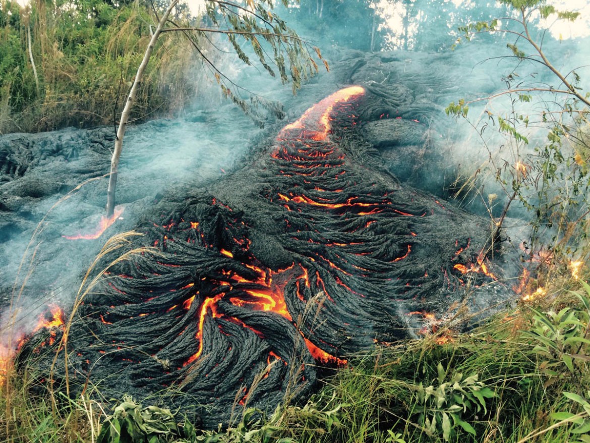
The first lava to be exuded by a volcano such as Kilauea is generally, but not always, hot (1,050°C) and quite runny. Because it is at its hottest, it is more fluid than any of the other forms. Where it flows onto a flat, near-horizontal surface, the lava may spread quite evenly and form a relatively smooth surface over quite a wide area. This is most likely to occur if the rate of lava emission is high, such that, any patches and lobes that begin to form are quickly re-melted and coalesced into a flat sheet of lava.
The surface cools rapidly and turns black by 900°C and forms a crust as the temperature falls to 750°C. Between these temperatures, the surface is ‘visco-elastic’ and this is the temperature range in which most variations of surface formation take place. Below these temperatures, the lava becomes rigidly solid and will only re-melt if buried by a considerable amount of hotter, fresher lava. Often, such a fluid lava flow will grow and deepen by inflation rather than by being flooded-over: fresh molten lava beneath the surface can push the surface upwards for a time, and may or may not then burst out. It is strange to watch a newly-crusted lava lobe begin to rise and expand like a balloon, before eventually splitting at some point and giving rise to a fresh lobe or flow.

Disrupted surface lava
A relatively fresh smooth surface of a lava flow or flood can be subjected to a resurgence of molten lava below. If this doesn’t last long, the hardening crust begins to crack and disturb the surface, perhaps with minor break-outs of lava. It can also break up the original surface into rafts of crust, which are shifted about by the underlying hot lava. The smooth lava can also be disturbed if the molten lava below drains away and the crust sinks; cracking and splitting, and perhaps forming mounds of radiating slabs.

Columnar lava
Where a large amount of lava has flowed and formed a layer several metres thick, it cools relatively slowly. As it cools, it shrinks. The slower it cools, the more regular are the shapes and cracks created by the shrinkage. These can form hexagonal columns that penetrate the depth of the lava. In the area of Kilauea, such columns are not formed as beauthifully and perfectly as, for instance, at the Giant’s Causeway in Northern Ireland. Instead, because they form at a lesser depth and have cooled quicker, the columns are only roughly formed.

Lobate lava
Most commonly in Hawaii, the outflow is not over a horizontal surface, nor a steep one, but down a gentle slope. In this case, it forms lobes of lava, which begin to crust over, burst out under their internal pressure and begin a new lobe. These lobes overtake, solidify, slide alongside and ride over the top of each other. I think of this kind of lava as ‘lobate’. It is almost always the kind that features on television recordings of flows, such as the one that took the houses at Kalapana in 2010.
Finger lava
The small lobes sometimes take the form of long protrusions, creating ‘finger lava’, which can seem to squirm and writhe slowly as the nose keeps pushing forwards, sometimes rising above the general surface as though to look around. The imagination can play with some of these forms – taking on the appearance of a swan’s neck, a Hawaiian ‘aloha’ wave, or a person, for instance. They are sometimes referred to as ‘toes’ of lava.

Folded lava
As the lobate lava flows, perhaps in some quantity, and the surface begins to cool, and harden, so the surface is pushed from beneath by the still very hot lava. Depending on the thickness of the hardening crust and the pressure of moving lava below, one thing that frequently happens is that the surface creases up and presses together, much like a table-cloth might rise in folds when pushed across a smooth table surface. This is ‘folded’ lava and it seems to form when the smooth or lobate lava surface has cooled for a time, and then slowly recommences its movement. At Kalapana, there are numerous examples of this beautiful lava formation. The surface is often a pearly silver-grey and can be very attractive in the sunlight.

Ropey lava
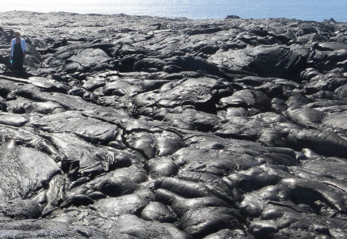
This is the one that is most commonly called pahoehoe lava. If the surface is continually cooling slightly and hardening just a little, the underlying movement can cause it to press together: the front edge cools the most; the following lava surface is being pushed and catches it up very quickly, and all gang up behind the leading edge. This creates the ropey appearance that is so well known, and which forms some of the most wonderful and creative patterns in the natural world. They can become extremely complex, as the pressure of moving lava varies with tiny changes in slope, the quantity being emitted and heat – including the weather on the day (cold rain, for instance). Patches of this ropey lava can be re-worked, overlain, twisted over and piled high in complex masses. Often, a flow will alternate between lobate and ropey lavas – beginning to heap up in a long chain one moment, and then a burst out of the side will begin the lobate sequence all over again.

The word ropey (or ropy) actually has two origins in this context: the appearance is like rope and, technically, any substance that is of a viscous nature and tends to form ropes or filaments can be referred to as ropey before it has solidified into shape – in the same way that it might be called sticky or plastic. Beneath the surface, there may well be a great depth of tangled sheets of ropey pathways and lobate masses, piled one on top of another as one phase of an eruption overtakes another. These may be minutes apart, or a year, within the same overall eruption – or up to 31 years in the case of Puʻu ʻŌʻō flowing south and east to the sea.
The varied layers can be seen in cracks all over the area – often very clearly marked by colour changes and with fresh seepages of lava squeezing between lower layers, showing that they are separate and not solidly fused together. Such intermediate squeezes are often signs that the lava surface has been pushed upwards – or inflated – by such later intrusions.


Cable lava
Depending on the exact temperature, rate of cooling, angle of slope and constituent minerals, the ropes of lava can become rolled and re-rolled over themselves by the moving mass beneath, creating lava surfaces like coils of great cables. This probably occurs if the lava has a considerable bulk, which is sufficient to keep the surface hot enough to remain pliable as it rolls and twists over a long enough period to produce such complicated formations. Some of these are very spectacular and awesome in their complexity.


Dribbles and spatter
Very vesicular lava can build up large bubbles below the surface, especially in vents, and these can burst upwards, sending a shower of lava across the local – or not so local – area. If they haven’t travelled far, they dribble and drip down anything they land on, forming spatter surfaces. Some definitions of lava may not include this as lava – as the material was thrown out of the volcano in explosive (sort of) eruptions, rather than being extruded, or oozed out, as lava should be. It seems to be a matter of where to draw the line: really explosive eruptions tend to produce material that isn’t always referred to as lava – ash, lapilli (pea-sized), tephra, scoria and cinder. However, these spatters and dribbles have the consistency of lava, look like lava and act like lava, so I include them here. Identical dribble formations can be formed when lava trickles over, for instance, a cliff – as at the abandoned and recent ‘ocean entry’ cliffs, west of Kalapana.

Swirls
The term ‘pahoehoe’ literally means ‘swirl’ in the Hawaiian language, not ‘ropey’. It refers specifically to the circular swirl in water made by the paddle of a canoe. Swirls can often be seen in the surface of the lava, where the speed of one part of the flow is greater than on the other side, causing a patch to rotate. These are often very distinct and may occur in the middle of a smooth patch of lobate lava, as well as being a feature of ropey lava. Also, these swirls are formed when the underlying mass begins to suck back down – usually briefly – and the lava tends to rotate like water going down a plughole, but much slower. They are called ‘sunbursts’ in some of the literature, particularly on the Internet.
Toothpaste
One seemingly separate form of lava found in Hawaii (and in other volcanic places, such as Tenerife) is the ‘toothpaste’ variety. This is formed where partly-stiffened lava is exuded through a gap in the lava surface for some time. It squeezes across the existing landscape like toothpaste and the surface of the new flow keeps the shape of the orifice from where it came. This can often result in a ‘roadway’ of grooved lava, frequently amid a flow of much more broken blocky lava.
This would occur if the main flow has formed a solid, heavily crusted surface, but then a fresh build-up of lava pressure below happens and, instead of pushing the front edge forward, the newer lava breaks through the surface. Existing blocks are thrust aside to create a new gap and the lava squeezes onto the surface. It generally suffers little subsequent alteration in shape and surface configuration, apart from settlement cracking. There are at least two very clear ones at Kumukahi near the lighthouse.

Broken slab lava
This is common in Hawaii. Near Kumukahi lighthouse, near the eastern tip of the island, there is a flow that has large areas of this material. It comprises mostly ropey or lobate lava, which has formed a solid crust and then been broken apart by renewed flow beneath. This breaks up the surface and jumbles it badly, creating a surface that is considered to be the most difficult of all the lava forms to walk on. There are slabs on edge, perhaps several metres high, with some areas of thin crust that is unsupported, with extremely sharp edges, and holes and cracks between the slabs that an unwary foot can drop into without any difficulty. Adding to the risk is the nature of the under-surface of many of the blocks – it is very often a ‘plucked’ surface, where the crust has pulled apart from the underlying lava. This creates a mass of needle-like spikes on one surface.

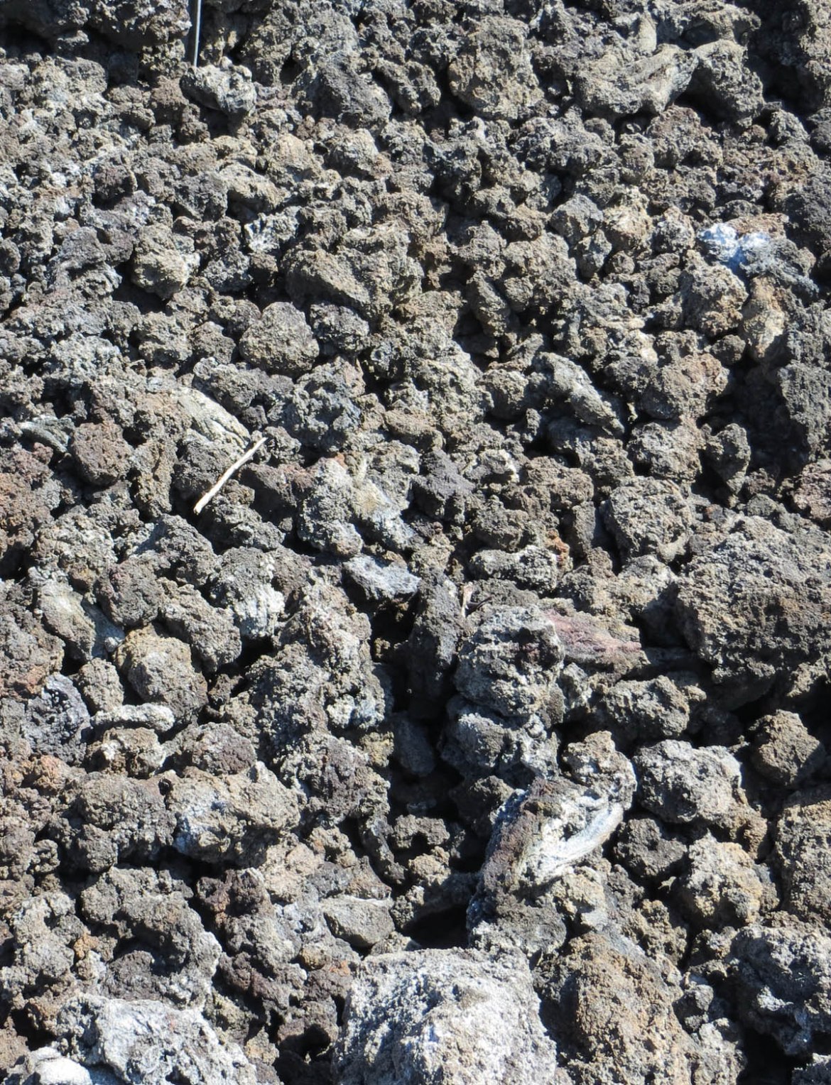
A’a – blocky lava
The second of the more ‘official’ lavas is also common in Hawaii. It comprises cindery blocks of mixed sizes, from a few centimetres to several metres across. Most commonly, this is fairly solidly welded together, especially if the flow was very active and then suddenly came to a halt while there was still a lot of heat within the flow to keep the blocks from completely hardening.


Cindery lava
“An advanced state of a’a senility” was one description of a particularly cindery, clinkery lava ‘flow’. It is found where an a’a flow is past its best but still moving, breaking its blocks into smaller and smaller pieces. These are then transported as loose blocks, still usually known as a’a lava, but the extremely loose nature of a cindery flow is very different to the trundling, semi-molten mass of a true a’a flow. The surface, and even deep down into the body of the flow, can become a mass of tumbled pieces simply piled together. It doesn’t really flow – it grinds, tumbles and crunches forward, landsliding down its own face.
As it is clinker, it can be very unstable, not even part-welded together, so it is treacherous to walk on, because blocks can shift suddenly underfoot. It is constantly crunching underfoot as it shifts, and climbing up or down a face of it can be extremely difficult and risky. There are examples of this around the eastern flows, although the best example that we saw wasn’t in Puna, but on the western coast road south of Kona Kailua towards Kaleakekua. Here, the 15m high face of a flow was composed of remarkably equally-sized cinder fragments – generally about 15cm to 30cm.

Pahoehoe versus a’a lava
There are various reasons for the differences between a’a and pahoehoe lavas. These are slight and are inter-related, including:
- The viscosity of the lava – how sticky it is, that is, how resistant it is to flowing. In turn, this depends mostly on its temperature.
- The temperature – the hotter, the runnier (a’a forms when the lava is slightly cooler).
- The shear strain – that is, how much of the lava is inclined to move its whole vertical depth compared with any particular layer or level within it. Does the whole mass move together or do layers shear apart and move at different speeds? This largely depends on what is in the lava – especially the gas content. For example, if there are widespread patches of vesicles (gas bubbles) within or between lava layers, they can act as a ‘friction-reduced surface’ between layers. Pahoehoe lava is relatively free of gas, as it has already escaped, due to the runniness of hot lava; whereas a’a lava generally has more bubbles and these can help different levels of a flow to slip and slide across each other, in effect, so jumbling them up.
- The crystal content (which is dependent on the exact mix of mineral content and the temperature at which various constituents will begin to crystallise). In truth, it has not been reliably demonstrated that the slight differences in the general basaltic nature of Kilauea’s lava makes any difference to the speed of flow or final morphology of the lava. After all, it is common for a pahoehoe flow to change to a’a; and when the source of the flow is rejuvenated and hot again, the new flow may well return to producing pahoehoe, which flows over the recent a’a beds.
- The sheer amount of moving lava (a’a flows tend to be thicker and, on average, are slower).
- The steepness of the slope (a thin hot lava will run down a steep slope almost like water, but a thick cooler lava will tumble along, as though pushed by a bulldozer).

Any or all of these factors can come into play – and a’a is common on near-horizontal land areas. It tends to move slowly along a broad united front, with the great majority of the flow moving at once as a facing wall of tumbling blocks. The flow of this type of lava tends to be akin to the movement of a tank track and, where a clinker block falls, it stays and is buried by falling lava from higher up on the advancing face. However, nothing is fixed. In the early days of the Kilauea flow through the Royal Gardens area in 1983, the a’a lava was up to 11m thick and was moving at a rate of up to 33m a minute. This works out at more than 40km in a day. It is fortunate that such a speed is rare and not sustained for long.

Pahoehoe lava tends to advance in lobes, which often become ropey along the central axis as the edges cool, slow down and retard the flow at the margins. Pahoehoe flows tend to advance at a number of separate points along a mostly static front. They are called ‘break-outs’ and are too runny to form a massive depth of flow all at once.

Around the Kumukahi lighthouse, there are further fields of this nature and it is common near Mauna Ulu to find areas where there have been flows of lobate/ropey lava that alternate with blocky lava, often reputed to have formed on the same day, by the same flow. As the runny lava cools, so it solidifies, perhaps into large thicknesses, which are being continually broken up by the continuing movement within the lava mass. It is common for the runny ropey and lobate lava to turn into a’a lava as it cools; but it is not possible for it to happen the other way round – as the lava cannot warm up and become more fluid. In places where ropey and lobate lava lie on top of blocky lava, the later deposit is from a renewed flow or a new one altogether. Such alternations are common along the lower length of the Chain of Craters Road, from Mauna Ulu.

General background
Hawaii is a volcanic island chain in the middle of the Pacific Ocean. It was formed by the Pacific Tectonic Plate moving gradually over a hotspot of rising magma. As the plate moves, so the magma reaches the surface (or ocean bed) in a new place every now and again. Big Island Hawaii is presently the most active land point above the hotspot, but a new one is developing to the southeast, forming a new volcano known as Lo’ihi, which will reach the ocean’s surface in about 10,000 years. As it is only about 30km from the south coast of Big Island, it will probably join up to form a single, even larger island in due course. Big Island is already almost twice the size of all the other Hawaiian islands put together, as a result of being a melding together of five different volcanoes.

Not the tallest at 1,231m, but probably the best known and currently most active, is Kilauea. It is linked to the volcanoes, Mauna Kea and Kohala, but has a separate magma chamber, which extends at least 60km into the earth. Mauna Loa and Hualalai are similarly linked to the volcano, Lo’ihi. The name Kilauea means ‘spreading far’ – the lava spreads a long way. It has deposited lava over the whole southeast of the island, as the other volcanoes have done over the rest of the Big Island.
The present summit caldera was formed in a series of eruptions and collapses beginning about 500 years ago. It is constantly changing, with walls collapsing, new eruptions and fire fountains occurring from time to time with little notice. On the volcano’s flanks, there are a number of cratered cones and rifts, which have erupted with varying degrees of vigour over the centuries. These ‘parasite’ volcanoes do not have their own magma chamber, but feed from underground conduits that spread from the main riser and may reach the surface through a crack or rift to form a linear or flatly conical vent. The flank volcano, which has been easily the most active since 1983, is Puʻu ʻŌʻō and is on the south-eastern slopes of the main volcano. The name means Hill of the ʻōʻō Bird (which is now extinct).

The flank of the volcano Puʻu ʻŌʻō is located on the eastern slopes of Kilauea, which has been the most active site in Hawaii since 1983. It has been in a state of constant eruption in one form or another – mostly sending lava through tubes and surface flows across great distances. This part of Puna District is where Kilauea’s most recent lava meets the sea. Many of the things mentioned below are associated with this volcano, but some are related to earlier eruptions of Kilauea. They are most easily visited from our first base at Kaimu, in Puna District.
A previously very active flank volcano is Mauna Ulu, which is located more to the south of the summit caldera, which is part of the Chain of Craters Road. These are most easily visited if based at Volcano Village, at the top of the mountain. At both centres, there is good accommodation and easy access to the lava.
Only a month or two after our 2013 visit, the flowing lava from Puʻu ʻŌʻō took a new course. It no longer gushed southwards to pour over the cliff into the sea in awe-inspiring falls, southwest of Kalapana. Instead, it began to find its way north-eastwards. Named after their starting dates, the ‘Thanksgiving Eve’ flow had given way to the ‘27 June’ flow. The new flow took a route through thin scrub forest and then into old cracks and tunnels, where its progress was not easily monitored. However, a few weeks before our 2014 visit, the flow suddenly returned mainly to the surface and headed through forest lands towards the small town of Pahoa and the Highway 130 road, which serves the whole of the southern part of Puna District. A couple of kilometres or so from Pahoa, the lava front stalled. Then, breakouts of lava occurred from further back. These caught up with the stationary front and soon overtook it.

Therefore, there was a state of some anxiety among the authorities, because the road at Pahoa may well have been breached, virtually isolating many small communities in the southeast tip of the island. The authorities banned walking out to the active lava front, and flights by helicopter or fixed-wing craft were not allowed within two nautical miles or lower than 1,200m at the active front. This was unfortunate, as the USGS flights days earlier had been at a low level and had captured good photographs and footage of the flow advancing through the forest. It was unofficially suggested that “around a dozen helicopters were hovering in the hot rising smoke above the lava at one time”, so some sort of curtailment was probably called for.
My emails and appeals to permit walking to the lava front resulted in the message that: “The last thing Hawaii needs is publicity for its volcanoes”. However, all was not lost, as we did manage the flight, and had done the other two activities the year before. From our accommodation in Kaimu (threatened daily with being cut off by the lava flow), it has been possible to see a huge amount of enthralling geology in the Puna District of Big Island.
The summer 2014 flow towards Pahoa
At the end of the 30-year flow southwards over the Chain of Craters Road and Kalapana, Puʻu ʻŌʻō turned its attention to the northeast on 27 June 2014. This is an unpopulated area, so initially, this was merely a nuisance to the people earning a living from guiding visitors out to see the flows and the ocean entry points. However, after two months, the leading tongue of this new flow dived into a series of caves and deep gullies, eventually filling them and continuing on the surface again along a very narrow line. After ponding up for a time, the leading edge then pushed on towards the small town of Pahoa, in a long narrow tongue.
During October, the lava’s maximum speed was about 180m a day over a front of up to one kilometre, but advances were intermittent across the length of the front. Before it actually stalled in November, the active front had slowed down to nine metres a day and then less. The flow’s energy seemed to be going into filling up the reservoir beneath the crust and inflating it, rather like a balloon. The lava then found several ways out (breakouts) on the north side of the flow. The most forward of these looked like overtaking the previous front and perhaps coalescing with it before continuing. Instead, there were breakouts much further back along the flow, considerably closer to Puʻu ʻŌʻō and, in mid-November 2014, the lava began to exude from the south side of the tongue across a wide front, but very slowly. This is facing the same general direction of the 1983 to 2014 flow and it remains to be seen if this will go anywhere, or if the Pahoa front will re-activate.
On Monday, 1 December 2014, a new breakout occurred further back from the most advanced point, on the north side. This sent a long tongue of lava down the slope, where the eventual distant point of the slope was the market at Pahoa, which moved at up to 300m a day. Also on that day, two tour guides working for a local company took a group out to view the active flow in what seems to have been a ‘test the system’ incident, as it was known that two ‘informants’ had joined the group. The tour guides were arrested and charged with “trespassing, reckless endangering and other misdemeanour offenses”. Authorities “are reminding the public that the area is closed and going in unauthorized could cost you up to $5,000 for your first offense.”
By Wednesday, 3 December, it looked as though a compromise was being sought, as “The public’s been clamouring for a close-up view of the lava”. The same day, the county announced plans to open a viewing area at the Pahoa Transfer Station, where the lava front stalled, although the active lava flows are still off limits. Civil Defence officials stated that the new lava flow front had advanced 380m since that Tuesday, but was still four kilometres away from Pahoa and Hwy 130 at that time (Figs. 4 and 5).
During the early part of 2015, Kilauea’s lava flow changed its nature entirely. The long tongue that was so close to Pahoa town centre stopped dead and has not been active since. Activity this year has been further back along the flow, mainly in a northerly direction into brush country, with very few inhabitants. The crater of Puʻu ʻŌʻō has been more active, and out-flowing in other directions. At the end of April 2015, the lava activity in the Halemaʻumaʻu Crater had increased, and the lava began to overflow the inner fire pit within the main crater of Kilauea.
By May 2015, the USGS had ceased to update their published maps and threat warnings for the Pahoa area on a daily basis at: http://hvo.wr.usgs.gov/activity/kilaueastatus.php.
In the next part of this article in the next issue of Deposits, I will discuss some of the highlights of our trip to Big Island, Hawaii.
Thanks to KITV Honolulu for the up-to-date information about the active flow and viewing possibilities provided on their website: http://www.kitv.com/news/lava-flow-viewing-area-to-open-on-big-island/30052326).
About the author
Trevor lives near Nottingham, England and is a retired teacher, headteacher and school inspector who has had a lifelong interest in geology, particularly volcanoes and dinosaur footprints. He and his wife have travelled worldwide to visit and climb more than a hundred volcanoes – active and otherwise. A few of these visits have been with organised groups, but most have been independent, and frequently involve camping.
| The other parts of this series can be found at: |
|---|
| Volcanoes of Big Island, Hawaii (Part 1) |
| Volcanoes of Big Island, Hawaii (Part 2) |
| Volcanoes of Big Island, Hawaii (Part 3) |